Imagine floating in the Pacific Ocean, thousands of kilometers from the nearest island, with no land in sight. At one particular location, astronauts passing overhead may be closer to you than anyone standing on a continent.
That extraordinary place is called point nemo.
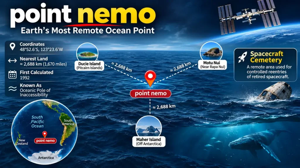
point nemo is the oceanic pole of inaccessibility, the location in Earth’s oceans farthest from any land. Situated in the South Pacific Ocean at approximately 48°52.6′S, 123°23.6′W, it lies about 2,688 kilometers (1,670 miles) from the nearest coastline. Its remarkable isolation also makes the surrounding region useful for controlled spacecraft reentries. National Ocean Service+1
Where Is point nemo Located?
point nemo lies in the remote South Pacific Ocean, far from major continents, populated islands, and busy coastal regions.
It is not an island, underwater mountain, or physical landmark. Instead, it is a mathematically calculated geographic position defined by its extraordinary distance from land.
Point Nemo (Pole of Inaccessibility) | KÜRE Encyclopedia
Geographic location of the oceanic pole of inaccessibility in the South Pacific.
Exact coordinates of point nemo
| Geographic detail | Value |
|---|---|
| Latitude | 48°52.6′ South |
| Longitude | 123°23.6′ West |
| Decimal coordinates | 48.8767°S, 123.3933°W |
| Ocean | South Pacific |
| Nearest land distance | Approximately 2,688 km |
| Distance in miles | Approximately 1,670 miles |
| Geographic classification | Oceanic pole of inaccessibility |
| First calculated | 1992 |
These are widely accepted approximate coordinates rather than the position of a permanently marked object. National Ocean Service+1
Which islands are closest to point nemo?
Three remote land locations define the geographic isolation of point nemo.
| Nearest land | Geographic region | Direction |
|---|---|---|
| Ducie Island | Pitcairn Islands | North |
| Motu Nui | Near Rapa Nui (Easter Island), Chile | Northeast |
| Maher Island | Off Antarctica | South |
Each lies approximately 2,688 kilometers from the calculated position.
Ducie Island is a remote, uninhabited coral atoll. Motu Nui is a small rocky islet near Rapa Nui, while Maher Island lies near Antarctica.
The presence of three nearly equidistant land points is central to how this oceanic location was calculated. National Ocean Service+1
Why Is point nemo Called the Oceanic Pole of Inaccessibility?
A pole of inaccessibility is a geographic location that is especially difficult to reach according to a defined distance measurement.
For oceans, the relevant measurement is the distance to the nearest land.
The oceanic pole of inaccessibility is therefore the position where that minimum distance is greater than at any other ocean location.
How scientists determine the farthest point from land
The calculation involves several steps:
- Represent Earth’s coastlines and islands using geographic data.
- Identify potential locations throughout the world’s oceans.
- Calculate the shortest surface distance from each location to land.
- Compare those minimum distances.
- Identify the ocean position with the greatest minimum distance.
This process must account for Earth’s curved surface, rather than treating the planet as a flat map.
The resulting point lies approximately equally far from three different coastal reference locations.
The calculation is not simply about finding the center of the largest ocean. Even tiny islands can significantly change which position is farthest from land.
Is point nemo the most isolated place on Earth?
It is the most isolated ocean location when isolation is measured by distance from land.
However, geographic isolation can have several meanings.
An uninhabited island might be extremely far from the nearest permanent settlement, while a remote inland location might be farthest from the ocean.
These are different geographic measurements.
point nemo holds a specific distinction: no other location in the world’s oceans is farther from its nearest landmass.
Who Discovered point nemo, and Why Is It Named Nemo?
The location was calculated in 1992 by Croatian-Canadian survey engineer Hrvoje Lukatela.
Rather than discovering it during an ocean expedition, Lukatela used geospatial computing to identify the most remote position in the ocean.
His calculation employed a geographic software system called Hipparchus, which helped determine distances across Earth’s curved surface.
This was an important example of how digital geographic analysis could solve a problem that would have been extremely difficult using traditional maps alone. Guinness World Records+1
The meaning behind the name
The name comes from Captain Nemo, the fictional submarine commander in Jules Verne’s 1870 novel Twenty Thousand Leagues Under the Sea.
Captain Nemo travels through the oceans aboard the submarine Nautilus, largely separated from ordinary human society.
The word nemo also means “no one” or “nobody” in Latin.
Both associations fit a place defined by its extraordinary remoteness.
Despite a common assumption, point nemo was not named after the animated fish from Finding Nemo, which was released in 2003, more than a decade after the geographic calculation. What Is Nemo Point?+1
Why Are Astronauts Sometimes the Closest Humans to point nemo?
One of the most fascinating facts about point nemo involves the International Space Station (ISS).
The ISS typically operates at an altitude of roughly 400 kilometers above Earth, although its altitude changes over time.
By comparison, the nearest land to point nemo is approximately 2,688 kilometers away.
When the space station passes sufficiently close overhead, astronauts aboard it may be physically closer to someone at the ocean location than people on land.
International Space Station over the Pacific Ocean – Bing Gallery · Peapix
The International Space Station can pass much closer to point nemo than the nearest land.
Does this mean astronauts are always the nearest people?
No.
The ISS continually orbits Earth, so its distance from point nemo changes throughout the day.
A ship passing through the surrounding ocean could also carry people much closer than the nearest coastline.
The astronaut comparison is therefore conditional, not permanent.
It illustrates how remote the location is, but it should not be interpreted as proof that the closest humans are always in space. Guinness World Records+1
Why Is point nemo Known as the Spacecraft Cemetery?
The ocean surrounding point nemo has another unusual role: it is associated with one of the world’s best-known spacecraft disposal regions.
This remote area of the South Pacific is commonly called the spacecraft cemetery or spacecraft graveyard.
Space agencies have used the broader region for controlled reentries of spacecraft that have reached the end of their operational lives.
Why spacecraft are directed toward this region
When satellites and spacecraft reenter Earth’s atmosphere, intense heating causes much of their structure to burn up.
However, some components can survive atmospheric reentry and reach Earth’s surface.
Large spacecraft may contain substantial metal structures and other components that do not completely disintegrate.
Directing surviving debris toward remote ocean regions helps reduce the risk to populated areas.
The South Pacific is suitable because it contains vast stretches of open water far from major settlements.
Importantly, the spacecraft cemetery is a broad disposal region, not a single target at the exact coordinates of point nemo. utmsi.utexas.edu+1
Which spacecraft have ended up near point nemo?
One famous example is the Russian space station Mir, which underwent a controlled atmospheric reentry in March 2001.
Its surviving debris was directed into a remote area of the South Pacific.
Numerous retired spacecraft, including cargo vehicles, have also been disposed of in the broader ocean region.
The purpose is not to preserve spacecraft underwater. It is to manage the risks associated with returning large objects from orbit.
Will the International Space Station crash near point nemo?
NASA and its international partners plan to retire the ISS after its operational life and conduct a controlled reentry into a remote ocean area.
NASA selected SpaceX in 2024 to develop a dedicated U.S. Deorbit Vehicle for this operation.
According to a 2026 U.S. Government Accountability Office report, the expected reentry was planned for the end of 2030 or early 2031, subject to program schedules.
The exact impact footprint will depend on the final deorbit plan. It should not be assumed that the station will land at the precise geographic coordinates of point nemo. NASA+1
Does the spacecraft cemetery damage the ocean?
Controlled ocean disposal reduces risks to human populations, but it does not automatically eliminate environmental concerns.
Surviving spacecraft components may settle on the seabed, introducing artificial materials into marine environments.
Potential considerations include debris accumulation, material composition, and disturbance of deep-sea habitats.
NASA’s environmental assessment for the ISS deorbit anticipates limited long-term impacts from the planned operation, although the assessment is specific to that mission. NASA+1
What Lives Near point nemo?
The extreme isolation of point nemo extends beyond its distance from land.
The surrounding waters are part of the South Pacific Gyre, a massive ocean circulation system characterized by relatively low biological productivity.
This region is sometimes described as an ocean desert.
That description does not mean the water is lifeless. Rather, the availability of nutrients supports less biological production than many coastal and nutrient-rich ocean regions.
Why the South Pacific Gyre has limited nutrients
A gyre is a large-scale system of circulating ocean currents shaped by prevailing winds, Earth’s rotation, and ocean-basin geography.
The South Pacific Gyre contains extensive areas where surface waters receive relatively little replenishment of nutrients from deeper layers.
Nutrients such as nitrogen, phosphorus, and iron influence the growth of phytoplankton, the microscopic organisms responsible for much of the ocean’s primary production.
When essential nutrients are scarce, phytoplankton growth is limited.
This affects the wider marine food web, including zooplankton, fish, and larger predators.
Scientific studies have documented exceptionally low productivity and nutrient limitation across parts of the South Pacific. Nature+1
Is there any marine life at point nemo?
Yes. The region is not biologically empty.
Marine microorganisms can survive in nutrient-poor waters, while specialized microbial communities inhabit deep marine sediments.
Researchers studying the South Pacific Gyre have found organisms capable of maintaining extremely low levels of metabolic activity.
Some of these communities survive under conditions where organic matter and available energy are remarkably limited.
A study published in Nature Communications reported that microbial communities in ancient, nutrient-poor marine sediments retained metabolic potential even in sediment dating back approximately 101.5 million years.
These findings concern the wider South Pacific Gyre rather than a complete biological survey of the exact point nemo coordinates. PubMed+1
Are there sharks, whales, or giant sea creatures?
Large marine animals can travel through remote ocean regions, but point nemo is not known as a special concentration area for sharks, whales, or other large animals.
The low availability of nutrients generally limits the productivity of the surrounding food web.
There is also no credible scientific evidence that the location contains unknown giant monsters or unusual supernatural creatures.
Its reputation for mystery comes primarily from geographic isolation, limited human activity, and popular storytelling.
Is point nemo Dangerous to Visit?
point nemo is not inherently dangerous because of a mysterious force or unusual geographic phenomenon.
Its main danger is isolation.
A vessel experiencing serious mechanical problems, a medical emergency, or severe weather could be extremely far from direct assistance.
Major challenges of reaching point nemo
Distance from rescue services
The nearest land is approximately 2,688 kilometers away. Even if a rescue organization receives a distress signal quickly, reaching a vessel may take considerable time.
Unpredictable Southern Ocean weather influences
The South Pacific can experience powerful weather systems, strong winds, and large ocean swells. Conditions depend on the season and specific weather patterns.
Limited nearby infrastructure
There are no permanent settlements, fuel stations, medical facilities, or harbors at the coordinates.
Communication requirements
Expeditions must rely on appropriate offshore communications, navigation systems, and emergency equipment.
Long-distance navigation
Reaching a particular ocean coordinate requires accurate positioning and careful voyage planning.
A journey to point nemo should therefore be treated as a serious offshore expedition rather than a conventional sightseeing trip.
Can ordinary tourists visit point nemo?
There is no general geographic prohibition on traveling to the location, subject to applicable maritime rules and operational restrictions.
However, no island, visitor center, hotel, or permanent platform exists there.
A properly equipped vessel could navigate to the coordinates, but doing so requires extensive preparation and sufficient supplies.
The location is sometimes encountered during long-distance ocean sailing, including passages through the remote South Pacific.
For most travelers, reaching it would be impractical because of the distance, expense, and logistical requirements.
How long would it take to reach point nemo?
Travel time depends on the departure location, vessel speed, weather, and route.
For illustration, consider a vessel traveling at a constant 10 knots.
A straight-line distance of approximately 1,451 nautical miles would require around 145 hours, or just over six days.
That is only a mathematical example based on the nearest-land distance, not a realistic itinerary from a usable port.
Actual voyages can take much longer because the closest land points do not provide convenient departure facilities, and vessels cannot always travel along an uninterrupted direct route.
point nemo Myths, Mysteries, and the Famous Bloop Sound
Few ocean locations have attracted as many dramatic claims as point nemo.
Stories about mysterious underwater sounds, enormous sea creatures, and unexplored ocean depths have helped turn this geographic coordinate into an internet curiosity.
Some stories are based on real scientific events, but their popular interpretations often go beyond the evidence.
Was the mysterious Bloop sound recorded near point nemo?
In 1997, underwater acoustic monitoring equipment detected an unusually powerful low-frequency sound in the South Pacific.
The signal became known as the Bloop.
Because of its unusual characteristics, it inspired speculation about enormous unidentified marine creatures.
The sound was detected in the wider South Pacific region, and popular accounts have associated it with point nemo.
However, its location should not be confused with proof of an event at the exact oceanic pole of inaccessibility.
Scientists subsequently linked similar acoustic signatures to ice-related activity, including the cracking and fracturing of large ice masses.
The Bloop is therefore not accepted as evidence of a giant unknown sea creature.
Is point nemo connected to Cthulhu?
Another unusual association comes from H. P. Lovecraft’s fictional universe.
In the 1928 story The Call of Cthulhu, the fictional sunken city of R’lyeh is located in the South Pacific.
Readers have noticed that the fictional coordinates place it in a broadly similar remote ocean region.
This resemblance has encouraged online speculation linking point nemo to the mythical entity Cthulhu.
The connection is literary rather than scientific.
There is no evidence that R’lyeh exists or that point nemo contains supernatural structures.
Has anyone explored the ocean floor there?
The South Pacific has been investigated through oceanographic expeditions, satellite observations, underwater instruments, and scientific drilling programs.
However, studying the broader region is not the same as comprehensively mapping every feature of the seabed at point nemo.
Deep-ocean exploration remains technically demanding because of water pressure, distance, and the cost of specialized equipment.
The limited amount of direct observation can make the region seem mysterious, but unexplored territory should not automatically be treated as evidence of extraordinary phenomena.
What Makes point nemo Different From Other Remote Places?
Several places on Earth are famous for isolation, but their remoteness is measured in different ways.
| Location | Type | Why it is notable |
|---|---|---|
| point nemo | Ocean coordinate | Farthest ocean location from land |
| Bouvet Island | Remote island | Extremely isolated uninhabited island |
| Tristan da Cunha | Inhabited archipelago | One of the world’s most isolated inhabited communities |
| Antarctic Pole of Inaccessibility | Continental location | Remote inland point defined by distance from the Antarctic coast |
point nemo vs. Bouvet Island
Bouvet Island is an isolated Norwegian territory in the South Atlantic Ocean.
Unlike point nemo, it is an actual landmass.
Its remoteness is measured in relation to other land locations, while point nemo is defined as the farthest position in the ocean from land.
The two represent different geographic categories.
point nemo vs. Tristan da Cunha
Tristan da Cunha is a remote inhabited archipelago in the South Atlantic.
Despite its isolation, it has a permanent community and local infrastructure.
point nemo has no population because it is simply an ocean coordinate.
Comparing the two highlights the distinction between the most isolated inhabited places and the most geographically remote ocean position.
Could another ocean location replace point nemo?
The designation is based on geographic calculations, so improved coastline measurements could refine the accepted coordinates.
Changes to coastlines, small islands, or geographic datasets may also affect highly precise calculations.
However, these refinements would not mean that the ocean location suddenly moved thousands of kilometers.
The accepted position remains in the South Pacific, approximately 2,688 kilometers from the nearest land.
Why point nemo Matters to Science and Geography
Beyond its unusual name and reputation, point nemo illustrates several important scientific ideas.
Understanding global geography
The location demonstrates how geographic information systems can identify extreme positions on Earth’s surface.
Its calculation involves coordinate systems, spherical geometry, geodesic distances, and coastline datasets.
These same underlying concepts are relevant to navigation, mapping, and geographic research.
Studying low-productivity marine ecosystems
The surrounding South Pacific Gyre provides opportunities to study organisms living in environments with limited nutrients and energy.
Research in these environments helps scientists understand microbial survival, ocean nutrient cycling, and the distribution of biological productivity.
It also offers insights into how life can persist under challenging conditions.
Managing spacecraft reentry risks
The remote South Pacific provides an example of how geography influences space operations.
Controlled reentry planning requires understanding orbital mechanics, atmospheric breakup, debris trajectories, and the distribution of human populations.
Selecting remote ocean impact areas is one way engineers reduce the risks associated with retiring large spacecraft.
Recognizing the limits of human exploration
Even with satellite navigation, modern ships, and advanced scientific instruments, some parts of the ocean remain difficult to investigate directly.
point nemo illustrates the difference between knowing a location’s coordinates and having detailed knowledge of everything occurring beneath its surface.
Conclusion: Why point nemo Is One of Earth’s Most Remarkable Locations
point nemo is more than a distant coordinate in the South Pacific. It is the oceanic pole of inaccessibility, approximately 2,688 kilometers from the nearest land and a striking example of Earth’s geographic extremes.
Calculated in 1992 by Hrvoje Lukatela, it has become associated with the International Space Station, the spacecraft cemetery, nutrient-poor ocean ecosystems, and popular mysteries about the deep sea.
Its defining feature, however, is simple: no other point in the world’s oceans is farther from land.
To understand its remoteness, examine its coordinates on a world map and compare its position with Ducie Island, Motu Nui, and Maher Island. That geographic relationship explains why point nemo continues to fascinate scientists, sailors, and curious readers alike.